The Surface Water Program held workshops to highlight streamflow monitoring needs in the State and to solicit additional monitoring recommendations.

Overview

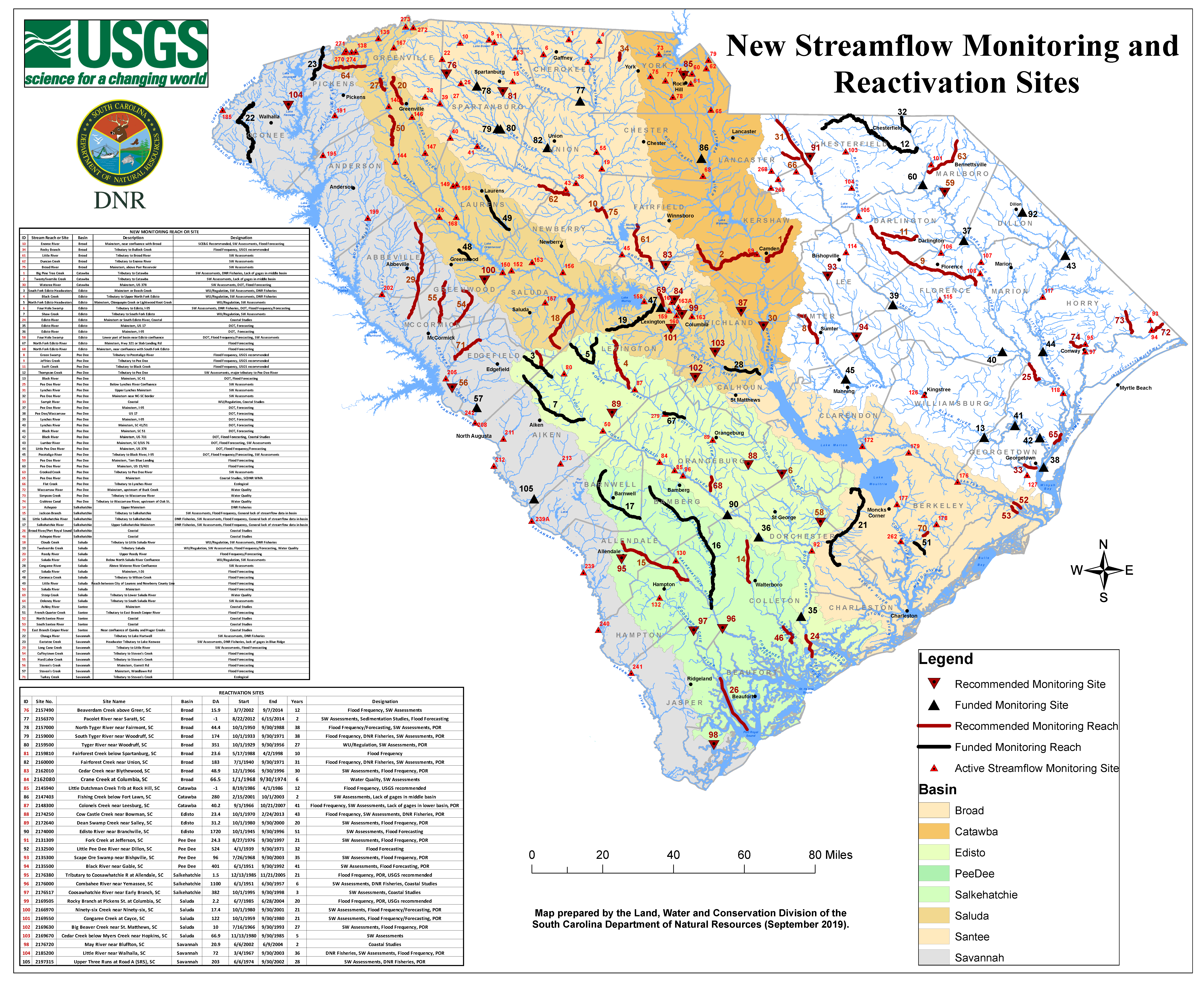
SCDNR hosted two streamflow monitoring workshops in early 2016 to highlight streamflow monitoring needs in the State and to solicit additional monitoring recommendations. The workshops were attended by a wide variety of stakeholders including local, state and federal agencies, water suppliers, power utilities and conservation groups. A total of 105 recommendations were made during these workshops. Since 2016, 40 of the recommendations have been funded by SCDNR or other State and Federal agencies. The map below shows the 105 recommendations and highlights the 40 newly funded sites (PDF version of this map - 8mb).

The 105 recommendations are also listed in the table below. The Reactivation Sites tab designates sites where the United States Geological Survey (USGS) has previously collected streamflow data but are not currently collecting data. The New Sites tabs are stream reaches or sites where the USGS has not previously collected data. Most sites are recommended for stream discharge measurements; however, conductivity monitoring also was recommended for several sites along the coast, while a few other sites in the State were recommended for stream discharge and water quality monitoring. The Funded Recommendations tab lists those sites or reaches that have been funded since the workshops in 2016.

USGS Real-time Streamflow Data

New Streamflow Monitoring and Reactivation Sites map image

Recommended New Sites

SiteBasinDescriptionDesignation
AshepooSalkehatchieUpper MainstemDNR Fisheries
Ashepoo RiverSalkehatchieCoastalCoastal Studies
Ashley RiverSanteeMainstemCoastal Studies
Big Pine Tree CreekCatawbaTributary to CatawbaSW Assessments, DNR Fisheries, Lack of gages in middle basin
Black CreekEdistoTributary to Upper North Fork EdistoWU/Regulation, SW Assessments, DNR Fisheries
Black RiverPee DeeMainstem, SC 41DOT, Flood Forecasting
Black RiverPee DeeMainstem, SC 51DOT, Forecasting
Black RiverPee DeeMainstem, US 701DOT, Flood Forecasting, Coastal Studies
Broad RiverBroadMainstem, above Parr ReservoirSW Assessments
Broad River/Port Royal SoundSalkehatchieCoastalCoastal Studies
Chauga RiverSavannahTributary to Lake HartwellSW Assessments, DNR Fisheries
Clouds CreekSaludaTributary to Little Saluda RiverWU/Regulation, SW Assessments, DNR Fisheries
Congaree RiverSaludaAbove Wateree River ConfluenceSW Assessments
Coronaca CreekSaludaTributary to Wilson CreekFlood Forecasting
Crabtree CanalPee DeeTributary to Waccamaw River, upstream of Oak St.Water Quality
Crooked CreekPee DeeTributary to Pee Dee RiverSW Assessments
Cuffeytown CreekSavannahTributary to Steven's CreekFlood Forecasting
Duncan CreekBroadTributary to Enoree RiverSW Assessments
East Branch Cooper RiverSanteeNear confluence of Quinby and Huger CreeksCoastal Studies
Eastatoe CreekSavannahHeadwater Tributary to Lake KeoweeSW Assessments, DNR Fisheries, lack of gages in Blue Ridge
Edisto RiverEdistoMainstem or South Edisto River, CoastalCoastal Studies
Edisto RiverEdistoMainstem, US 17DOT, Forecasting
Edisto RiverEdistoMainstem, I-95DOT, Forecasting
Enoree RiverBroadMainstem, near confluence with BroadSCE&G Recommended, SW Assessments, Flood Forecasting
Flat CreekPee DeeTributary to Lynches RiverEcological
Four Hole SwampEdistoTributary to Edisto, I-95SW Assessments, DNR Fisheries, DOT, Flood Frequency/Forecasting
Four Hole SwampEdistoLower part of basin near Edisto confluenceDOT, Flood Frequency/Forecasting, SW Assessments
French Quarter CreekSanteeTributary to East Branch Cooper RiverFlood Forecasting
Green SwampPee DeeTributary to Pocotaligo RiverFlood Frequency, USGS recommended
Hard Labor CreekSavannahTributary to Steven's CreekFlood Forecasting
Jackson BranchSalkehatchieTributary to SalkehatchieSW Assessments, Flood Frequency, General lack of streamflow data in basin
Jeffries CreekPee DeeTributary to Pee DeeFlood Frequency, USGS recommended
Little Pee Dee RiverPee DeeMainstem, US 378DOT, Flood Frequency/Forecasting
Little RiverSaludaReach between City of Laurens and Newberry County LineFlood Forecasting
Little RiverBroadTributary to Broad RiverSW Assessments
Little Salkehatchie RiverSalkehatchieTributary to SalkehatchieDNR Fisheries, SW Assessments, Flood Frequency, General lack of streamflow data in basin
Long Cane CreekSavannahTributary to Little RiverSW Assessments, Flood Forecasting
Lumber RiverPee DeeMainstem, SC 9/US 76DOT, Flood Forecasting, SW Assessments
Lynches RiverPee DeeUpper Lynches MainstemSW Assessments
Lynches RiverPee DeeMainstem, I-95DOT, Forecasting
Lynches RiverPee DeeMainstem, SC 41/51DOT, Forecasting
North Fork Edisto HeadwatersEdistoMainstem, Chinquapin Creek or Lightwood Knot CreekWU/Regulation, SW Assessments
North Fork Edisto RiverEdistoMainstem, Hwy 321 or Slab Landing RdFlood Forecasting
North Fork Edisto RiverEdistoMainstem, near confluence with South Fork EdistoFlood Forecasting
North Santee RiverSanteeCoastalCoastal Studies
Oolenoy RiverSaludaTributary to South Saluda RiverSW Assessments
Pee Dee RiverPee DeeBelow Lynches River ConfluenceSW Assessments
Pee Dee RiverPee DeeMainstem near NC-SC borderSW Assessments
Pee Dee RiverPee DeeMainstem, I-95DOT, Forecasting
Pee Dee RiverPee DeeMainstem, Tom Blue LandingFlood Forecasting
Pee Dee RiverPee DeeMainstem, US 15/401Flood Forecasting
Pee Dee RiverPee DeeMainstemCoastal Studies, SCDNR WMA
Pee Dee/WaccamawPee DeeUS 17DOT, Forecasting
Pocotaligo RiverPee DeeTributary to Black River, I-95DOT, Flood Frequency/Forecasting, SW Assessments
Reedy RiverSaludaUpper Reedy RiverFlood Frequency/Forecasting
Rocky BranchBroadTributary to Bullock CreekFlood Frequency, USGS recommended
Salkehatchie RiverSalkehatchieUpper Salkehatchie MainstemDNR Fisheries, SW Assessments, Flood Frequency, General lack of streamflow data in basin
Saluda RiverSaludaBelow North Saluda River ConfluenceWU/Regulation, SW Assessments
Saluda RiverSaludaMainstem, I-26Flood Forecasting
Saluda RiverSaludaMainstemFlood Forecasting
Sampit RiverPee DeeCoastalWU/Regulation, Coastal Studies
Shaw CreekEdistoTributary to South Fork EdistoWU/Regulation, SW Assessments
Simpson CreekPee DeeTributary to Waccamaw RiverWater Quality
South Fork Edisto HeadwatersEdistoMainstem or Beech CreekWU/Regulation, SW Assessments, DNR Fisheries
South Santee RiverSanteeCoastalCoastal Studies
Steven's CreekSavannahMainstem, Garrett RdFlood Forecasting
Steven's CreekSavannahMainstem, Woodlawn RdFlood Forecasting
Stoop CreekSaludaTributary to Lower Saluda RiverWater Quality
Swift CreekPee DeeTributary to Black CreekFlood Frequency, USGS recommended
Thompson CreekPee DeeTributary to Pee DeeSW Assessments, major tributary to Pee Dee River
Turkey CreekSavannahTributary to Steven's CreekEcological
Twelvemile CreekSaludaTributary SaludaWU/Regulation, SW Assessments, Flood Frequency/Forecasting, Water Quality
Twentyfivemile CreekCatawbaTributary to CatawbaSW Assessments, Lack of gages in middle basin
Waccamaw RiverPee DeeMainstem, upstream of Buck CreekWater Quality
Wateree RiverCatawbaMainstem, US 378SW Assessments, DOT, Flood Forecasting

Download a CSV file of this table.

Recommended Reactivation Sites

Site No.SiteBasinDAStartEndYearsDesignation
2157490Beaverdam Creek above Greer, SCBroad15.93/7/20029/7/201412Flood Frequency, SW Assessments
2156370Pacolet River near Saratt, SCBroad-1.08/22/20126/15/20142SW Assessments, Sedimentation Studies, Flood Forecasting
2157000North Tyger River near Fairmont, SCBroad44.410/1/19509/30/198838Flood Frequency/Forecasting, SW Assessments, POR
2159000South Tyger River near Woodruff, SCBroad174.010/1/19339/30/197138Flood Frequency, DNR Fisheries, SW Assessments, POR
2159500Tyger River near Woodruff, SCBroad351.010/1/19299/30/195627WU/Regulation, SW Assessments, POR
2159810Fairforest Creek below Spartanburg, SCBroad23.65/17/19884/2/199810Flood Frequency
2160000Fairforest Creek near Union, SCBroad183.07/1/19409/30/197131Flood Frequency, DNR Fisheries, SW Assessments, POR
2162010Cedar Creek near Blythewood, SCBroad48.912/1/19669/30/199630SW Assessments, Flood Frequency, POR
2162080Crane Creek at Columbia, SCBroad66.51/1/19689/30/19746Water Quality, SW Assessments
2145940Little Dutchman Creek Trib at Rock Hill, SCCatawba-1.08/19/19864/1/198612Flood Frequency, USGS recommended
2147403Fishing Creek below Fort Lawn, SCCatawba280.02/15/200110/1/20032SW Assessments, Lack of gages in middle basin
2148300Colonels Creek near Leesburg, SCCatawba40.29/1/196610/21/200741Flood Frequency, SW Assessments, Lack of gages in lower basin, POR
2174250Cow Castle Creek near Bowman, SCEdisto23.410/1/19702/24/201343Flood Frequency, SW Assessments, DNR Fisheries, POR
2172640Dean Swamp Creek near Salley, SCEdisto31.210/1/19809/30/200020SW Assessments, Flood Frequency, POR
2174000Edisto River near Branchville, SCEdisto1720.010/1/19459/30/199651SW Assessments, Flood Forecasting
2131309Fork Creek at Jefferson, SCPee Dee24.38/27/19769/30/199721SW Assessments, Flood Frequency, POR
2132500Little Pee Dee River near Dillon, SCPee Dee524.04/1/19399/30/197132Flood Forecasting
2135300Scape Ore Swamp near Bishpville, SCPee Dee96.07/26/19689/30/200335SW Assessments, Flood Frequency, POR
2135500Black River near Gable, SCPee Dee401.06/1/19519/30/199241SW Assessments, Flood Forecasting, POR
2176380Tributary to Coosawhatchie R at Allendale, SCSalkehatchie1.512/13/198511/21/200521Flood Frequency, POR, USGS recommended
2176000Combahee River near Yemassee, SCSalkehatchie1100.06/1/19516/30/19576SW Assessments, DNR Fisheries, Coastal Studies
2176517Coosawhatchie River near Early Branch, SCSalkehatchie382.010/1/19959/30/19983SW Assessments, Coastal Studies
2176720May River near Bluffton, SCSavannah20.96/6/20026/9/20042Coastal Studies
2169505Rocky Branch at Pickens St. at Columbia, SCSaluda2.26/7/19856/28/200420Flood Frequency, POR, USGs recommended
2166970Ninety-six Creek near Ninety-six, SCSaluda17.410/1/19809/30/200121SW Assessments, Flood Frequency/Forecasting, POR
2169550Congaree Creek at Cayce, SCSaluda122.010/1/19599/30/198021SW Assessments, Flood Frequency/Forecasting, POR
2169630Big Beaver Creek near St. Matthews, SCSaluda10.07/16/19669/30/199327SW Assessments, Flood Frequency, POR
2169670Cedar Creek below Myers Creek near Hopkins, SCSaluda66.911/13/19809/30/19855SW Assessments
2185200Little River near Walhalla, SCSavannah72.03/4/19679/30/200336DNR Fisheries, SW Assessments, Flood Frequency, POR
2197315Upper Three Runs at Road A (SRS), SCSavannah203.06/6/19749/30/200228SW Assessments, DNR Fisheries, POR

*DA: Drainage area in square miles, -1 denotes that drainage area is not listed on USGS website or the site is a tidal creek

Download a CSV file of this table.

All Funded Recommendations

SiteBasinDescriptionDesignationNotes
South Fork Edisto HeadwatersEdistoMainstem or Beech CreekWU/Regulation, SW Assessments, DNR FisheriesReal Time Discharge
North Fork Edisto HeadwatersEdistoMainstem, Chinquapin Creek or Lightwood Knot CreekWU/Regulation, SW AssessmentsReal Time Discharge
Shaw CreekEdistoTributary to South Fork EdistoWU/Regulation, SW AssessmentsReal Time Discharge
Thompson CreekPee DeeTributary to Pee DeeSW Assessments, major tributary to Pee Dee RiverReal Time Discharge
Black RiverPee DeeMainstem, SC 41DOT, Flood ForecastingReal Time Discharge
Little Salkehatchie RiverSalkehatchieTributary to SalkehatchieDNR Fisheries, SW Assessments, Flood Frequency, General lack of streamflow data in basinReal Time Discharge
Salkehatchie RiverSalkehatchieUpper Salkehatchie MainstemDNR Fisheries, SW Assessments, Flood Frequency, General lack of streamflow data in basinReal Time Discharge
Twelvemile CreekSaludaTributary SaludaWU/Regulation, SW Assessments, Flood Frequency/Forecasting, Water QualityReal Time Discharge
Ashley RiverSanteeMainstemCoastal StudiesReal Time Stage
Chauga RiverSavannahTributary to Lake HartwellSW Assessments, DNR FisheriesReal Time Discharge
Eastatoe CreekSavannahHeadwater Tributary to Lake KeoweeSW Assessments, DNR Fisheries, lack of gages in Blue RidgeReal Time Discharge
Congaree RiverSaludaAbove Wateree River ConfluenceSW AssessmentsReal Time Stage
Pee Dee RiverPee DeeMainstem near NC-SC borderSW AssessmentsReal Time Discharge
Edisto RiverEdistoMainstem, US 17DOT, ForecastingRapid Deployment Gage
Edisto RiverEdistoMainstem, I-95DOT, ForecastingReal Time Discharge
Pee Dee RiverPee DeeMainstem, I-95DOT, ForecastingReal Time Stage, Pier Scour
Pee Dee/WaccamawPee DeeUS 17DOT, ForecastingReal Time Stage
Lynches RiverPee DeeMainstem, I-95DOT, ForecastingReal Time Stage, Pier Scour
Lynches RiverPee DeeMainstem, SC 41/51DOT, ForecastingRapid Deployment Gage
Black RiverPee DeeMainstem, SC 51DOT, ForecastingRapid Deployment Gage
Black RiverPee DeeMainstem, US 701DOT, Flood Forecasting, Coastal StudiesRapid Deployment Gage
Lumber RiverPee DeeMainstem, SC 9/US 76DOT, Flood Forecasting, SW AssessmentsReal Time Discharge
Little Pee Dee RiverPee DeeMainstem, US 378DOT, Flood Frequency/ForecastingRapid Deployment Gage
Pocotaligo RiverPee DeeTributary to Black River, I-95DOT, Flood Frequency/Forecasting, SW AssessmentsReal Time Stage, Pier Scour
Saluda RiverSaludaMainstem, I-26 (I-20)Flood ForecastingReal Time Discharge, Installation site upstream on I-20 crossing
Coronaca CreekSaludaTributary to Wilson CreekFlood ForecastingReal Time Discharge
Little RiverSaludaReach between City of Laurens and Newberry County LineFlood ForecastingReal Time Discharge
French Quarter CreekSanteeTributary to East Branch Cooper RiverFlood ForecastingReal Time Stage
Steven's CreekSavannahMainstem, Woodlawn RdFlood ForecastingReal Time Stage
Pee Dee RiverPee DeeMainstem, US 15/401Flood ForecastingRapid Deployment Gage
North Fork Edisto RiverEdistoMainstem, Hwy 321 or Slab Landing RdFlood ForecastingReal Time Discharge
Pacolet RiverBroadUSGS 2156370, Pacolet River near Saratt, SCSW Assessments, Sedimentation Studies, Flood ForecastingReal Time Discharge
North Tyger RiverBroadUSGS 2157000, North Tyger River near Fairmont, SCFlood Frequency/Forecasting, SW Assessments, PORReal Time Discharge
South Tyger RiverBroadUSGS 2159000, South Tyger River near Woodruff, SCFlood Frequency, DNR Fisheries, SW Assessments, PORReal Time Discharge, Installation at USGS 2158408 upstream
Tyger RiverBroadUSGS 2159500, Tyger River near Woodruff, SCWU/Regulation, SW Assessments, PORReal Time Discharge
Fairforest CreekBroadUSGS 2160000, Fairforest Creek near Union, SCFlood Frequency, DNR Fisheries, SW Assessments, PORReal Time Discharge
Fishing CreekCatawbaUSGS, 2147403, Fishing Creek below Fort Lawn, SCSW Assessments, Lack of gages in middle basinReal Time Discharge
Edisto RiverEdistoUSGS 2174000, Edisto River near Branchville, SCSW Assessments, Flood ForecastingReal Time Discharge
Little Pee Dee RiverPee DeeUSGS 2132500, Little Pee Dee River near Dillon, SCFlood ForecastingReal Time Discharge
Upper Three RunsSavannahUSGS 2197315, Upper Three Runs at Road A (SRS), SCSW Assessments, DNR Fisheries, PORReal Time Discharge, Installation site upstream of original recommendation

Download a CSV file of this table.

Definitions Table

DesignationPurpose
Flood Frequency SiteWill be used to determine flood frequencies and magnitudes.
Flood Forecasting SiteWill be used for forecasting flood events and are important for public safety.
SW Assessment SiteWill be used to improve UIFs (Unimpaired Flows) for model development as part of the State's Surface Water Assessment Project. These UIFS are used to develop inflows to the surface water allocation models being developed by the SCDES and a consultant (CDM Smith).
POR SitePeriod of Record (for reactivation sites only) - site has 20 or more years of historic data from which to compare new streamflow data.
DNR Fisheries SiteWill be used by SCDNR biologists for monitoring and fisheries assessment, management and protection.
Coastal Studies SiteWill help define location of the saltwater/freshwater interface and help determine rate of salt water intrusion.
WU/Regulation SiteSite is regulated or has impairment (downstream of a reservoir, notable water use/withdrawals, etc.), and data will be used to assess water availability concerns.
DOT SiteWill be at a bridge crossing and will address DOT infrastructure and transportation concerns.
Water QualityWill be used to monitor water quality
EcologicalWill be used to monitor and study a stream of noted ecological value or concern
Other purposes include the general lack of data availability on a mainstem, a major tributary, or in a particular part of a basin.
Though not listed explicitly, many of the proposed sites can also be used for low flow studies (7Q10 estimates, for example) or for drought monitoring.

Workshop Presentations

Streamflow Workshop I (2/3/2016)

Streamflow Workshop II (3/10/2016)

For questions regarding these presentations, please contact Scott Harder by phone (864-986-6254) or email (harders@des.sc.gov).