 To protect sensitive coastal waters, avoid future use and access conflicts, and assist in comprehensive coastal management, SCDES BCM requires the development of Dock Master Plans (DMPs) along the shoreline of properties undergoing development. There are two forms of DMP authorization requests, including 1) a DMP critical area permit application for the construction of all future dock, piers, and boat ramps in the development, or (2) preparation of a conceptual DMP which guides the individual permitting of all future docks, piers, and boat ramps in the development. If the applicant decides to pursue a DMP critical area permit, normal SCDES BCM permitting procedures must be followed. If the applicant decides to prepare a conceptual DMP, the following procedures must be followed.
Procedures for Conceptual DMPs
- If lands adjacent to navigable coastal waters are developed and such development requires Coastal Zone Consistency (CZC) certification, the landowner or developer must submit a DMP which provides basic information about the property and proposed uses of the adjacent State waters and marshes. If a development is to proceed in two or more phases, these procedures are only required for the phase seeking consistency determination. Only a DMP depicting the phases and the estimated number of docks for each phase will be required for the remainder of the development, to be updated as DMPs are prepared for consistency determination in future phases. It is understood that phases not undergoing development may be subject to change.
- The conceptual DMP document will be annotated by SCDES BCM staff to reflect coastal management and environmental concerns, to include recommended revisions to the conceptual DMP to address or alleviate those concerns; if no concerns are identified, SCDES BCM will find the DMP conceptually consistent with the Coastal Zone Management Program, subject to any site-specific concerns identified through any future permit applicants. SCDES BCM comments will be transmitted to the applicant with a copy placed on file at SCDES BCM. If any facts are disputed, the applicant may submit further comments and information which will be made part of the file; SCDES BCM staff will attempt to reconcile the disputed facts. No further action is required by the applicant.
- A DMP which is conceptually consistent does not guarantee issuance of any dock permits. The conceptual DMP will be used as a guideline and an additional consideration when dock critical area permitting applications are made. As with all applications reviewed by SCDES BCM, the project will be judged on its own merits as well as compliance with the Coastal Tidelands and Wetlands Act, Coastal Division Regulations, and the Coastal Management Program Document.
Applying for a DMP
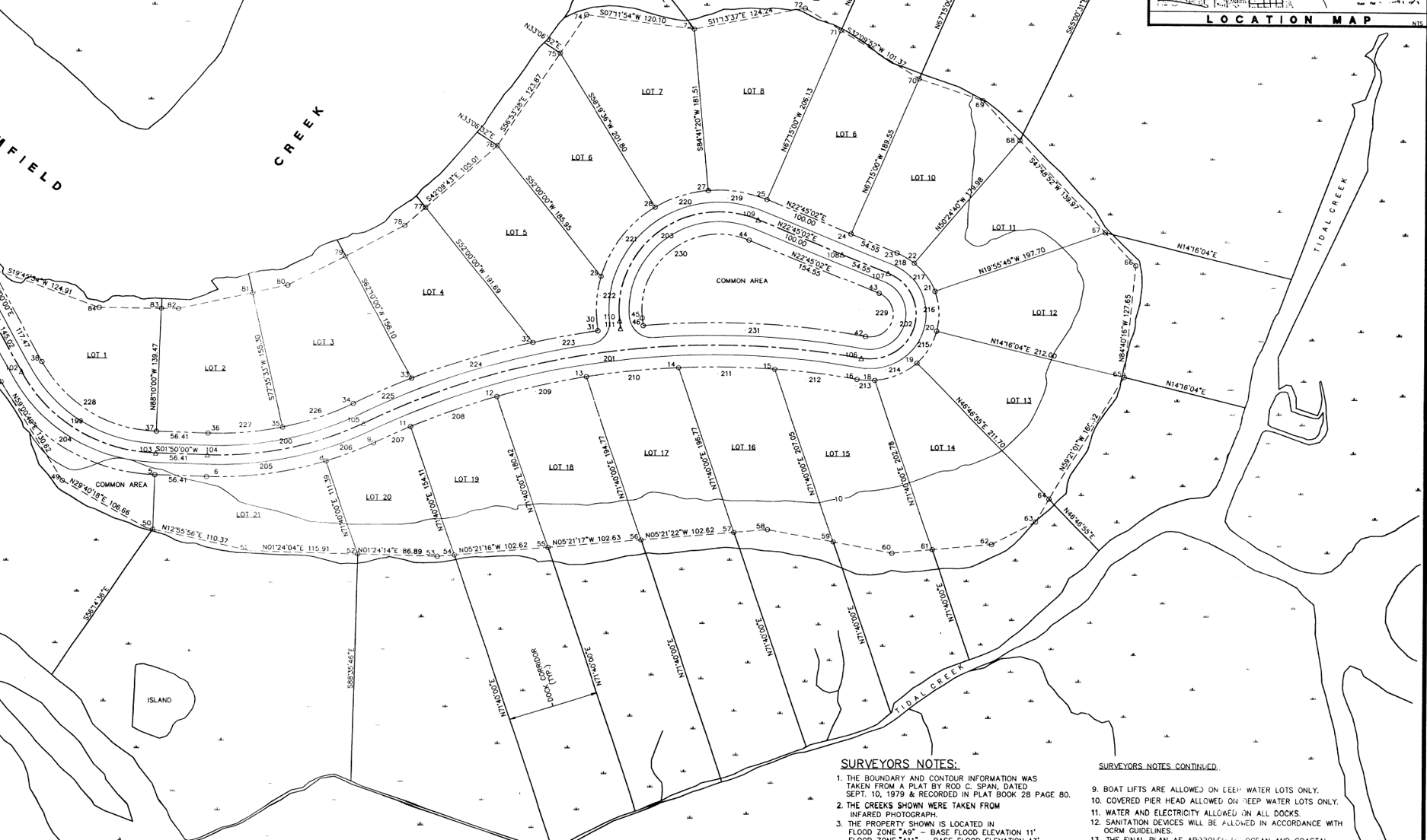
A DMP, either as a general permit or as a conceptual master plan, must be submitted for all projects subject to SCDES BCM consistency certification. A DMP request can be submitted via ePermitting using the BCM Critical Area Activities application form. DMPs must be submitted on a site plan prepared by an engineer, surveyor, or landscape architect licensed and registered in the State of South Carolina. The plan may be shown in conjunction with any other site drawings, i.e., storm water, wetlands, etc., but must contain the following:
- Property lines, both existing and proposed.
- The critical area line which has been approved by SCDES BCM.
- The adjoining water bodies, accurately portrayed as to location and size. The channelward edge of marsh vegetation and the location, width and depth of the main creek channel must be depicted, as well as any other creeks, inlets, or sloughs in excess of 20 feet in width.
- The proposed dock corridors must be shown on the site plan as property line extensions. The corridors must be referenced to a recoverable reference point. The dock corridor is defined as a pair or more of recoverable lines extending from the property lines toward open water between which a dock may be constructed. The extended lines should normally be a straight line extension of the property line but may vary to accommodate site specific conditions.
- All docks existing on the water body in the vicinity of the proposed docks must be accurately shown on the plat, both as to size and location. On smaller creeks of less than 50 feet in width, existing docks on the opposite bank must be shown.
- All proposed community docks, boat ramps and other SCDES BCM permitted structures must be shown on the plat.
- If the plat is of an area covered by an existing dock plan prepared by SCDES BCM or another governmental body, the dock corridor plan shown on the plat must reflect this plan.
- Any deed restrictions of the property that would affect dock size or placement must be shown on the plat.
- Individual docks on lots should not be shown on the plan; but rather, the estimated total project number of docks along a specified shoreline of common ownership, along with information concerning the typical size of proposed docks and floats. The size of the proposed docks will be used as indication of the approximate size of vessels which would use the proposed docking facilities.
- The spacing, location, and length of dock corridors must be in accordance with SCDES BCM Coastal Division Regulations for permits for DMPs.
Review of DMP Applications
To reduce negative impacts, all DMPs are evaluated as to the suitability of providing individual docks for every waterfront lot. Although in some situations single family docks are appropriate, more favorable consideration will be given to the use of community docks and joint use docks. In making this evaluation, the following factors will be considered:
- Proximity to alternative access (boat ramps, marinas, community docks and others).
- Size of a navigable channel.
- Size of lots (water frontage).
- Distance to open water.
- Environmental sensitivity of adjacent waters and coastal resources.
- Impact of proposed docks on Geographic Areas of Particular Concern (GAPCs), including access to those GAPCs.
- Other possible development and the general character of the area, including impacts to adjacent property owners.
- The degree to which construction of a dock or docks will affect public access to public waters and the traditional recreational uses of the water body including fishing, crabbing, and oystering.
Implementation of DMPs
Reference must be given to the Department approved DMP in all contracts for sale of affected lots. DMPs will be filed with SCDES BCM, available for public review, and used for consideration of future permit decisions. The DMP shall be presumed to take precedence over applications inconsistent with such plan unless new information is revealed in the application to address and overcome concerns identified in the DMP. Revisions to DMPs will follow the same agency review procedure as outlined for new plans.
Contact
SCDES BCM staff are available to assist property owners. If you suspect authorization may be required for your activity, or if you have questions related to authorization requirements, please contact SCDES BCM’s Critical Area Permitting Section at (843) 953-0200, or visit the Project Manager Finder Application to find contact information for project managers by geographic area.